Smarter Directions: Google Maps Uses Artificial Intelligence to Guide You by What You See.
Gallery
Videos
Google is redefining navigation by making its directions sound more human and intuitive. The company has begun rolling out a new AI-powered feature in the United States that uses Gemini to identify and reference real-world landmarks along your route, making turn-by-turn navigation easier to follow.
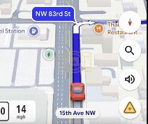
Instead of the standard “turn right in 500 feet,” users will now hear more natural instructions like “turn right after the Thai Siam Restaurant” — with the landmark visually highlighted on-screen. The system draws from Gemini’s ability to cross-reference over 250 million mapped places with Google’s extensive Street View imagery, identifying visible and recognizable landmarks such as restaurants, gas stations, and iconic buildings.
The breakthrough lies in Gemini’s capacity to analyze what drivers can actually see, solving one of the most common pain points in navigation — spatial distance estimation. By connecting visual data to real-world context, Google Maps can now guide users based on familiar sights rather than abstract measurements, bridging the gap between digital navigation and human perception.
According to Google engineers, this update represents a major leap in contextual AI for everyday use. It not only enhances user experience but also improves accessibility, helping people navigate unfamiliar areas more confidently and naturally. For now, the feature is rolling out across the U.S., with global expansion expected in the coming months.
As Google continues to integrate Gemini across its ecosystem, this update signals how artificial intelligence is reshaping the simplest aspects of daily life — starting with the way we find our way home.