היסטארישער ווינטער שטורעם באגראבט צפון-מזרח אונטער צוויי פוס שניי.
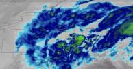
A powerful nor’easter, officially designated Winter Storm Hernando, unleashed a historic blizzard across the Northeastern United States, delivering more than a foot of snowfall to numerous locations and producing near whiteout conditions across major population centers. Satellite imagery captured the storm’s rapid intensification into a bomb cyclone as it tracked along the Atlantic coastline, with dense cloud bands and heavy precipitation sweeping inland from the Mid-Atlantic through New England.
Meteorologists confirmed that the system underwent bombogenesis, a process in which atmospheric pressure drops at least 24 millibars within 24 hours, dramatically strengthening the storm. This rapid deepening enhanced moisture convergence and intensified snowfall rates, leading to accumulations exceeding 24 inches in parts of New England and the Mid-Atlantic. The combination of heavy snow and hurricane-force wind gusts surpassing 80 miles per hour created blizzard conditions, severely reducing visibility and producing extensive drifting.
The impact on infrastructure has been widespread. More than one million customers experienced power outages as heavy, wet snow and high winds brought down transmission lines and trees. Major highways were rendered impassable, airports halted operations across multiple states, and rail services faced significant delays and cancellations, disrupting travel for millions. Emergency services responded to hundreds of weather-related incidents, and authorities confirmed at least two fatalities linked to storm conditions.
Satellite loop data from GOES-East illustrated the storm’s classic nor’easter structure, with color-coded precipitation bands intensifying as the system moved northeastward. The heaviest snowfall aligned with the deformation zone northwest of the storm’s coastal low, a hallmark of high-impact winter cyclones. Coastal areas also experienced significant blowing snow and localized flooding due to strong onshore winds.
Nor’easters form from the collision of cold Arctic air masses with warm, moisture-rich air over the Atlantic Ocean, a contrast that fuels rapid cyclogenesis. Climatological records from the National Oceanic and Atmospheric Administration indicate that the frequency of high-intensity extratropical cyclones affecting the region has increased in recent decades, a trend associated with warmer ocean surface temperatures that provide additional latent heat energy to developing systems.
Winter Storm Hernando stands as one of the most severe winter weather events to strike the Northeast in the past decade, both in terms of snowfall totals and the scale of disruption. As the system continues to move eastward into the Atlantic, recovery efforts are underway, with utility crews working to restore power, transportation agencies clearing critical corridors, and emergency management officials urging residents to remain cautious amid lingering hazardous conditions.
גאלערי
ווידעאס