א פרישע שניי שטורעם איבערן וואך קען ברענגען שווערע שניי און שטארקע ווינטן.
גאלערי
ווידעאס
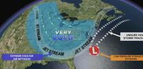
Meteorologists are closely tracking another potential winter storm expected to impact the Northeast between January 31 and February 1, 2026, with forecast models showing two primary tracks that could significantly affect snowfall totals and overall impacts. The developing nor’easter is tied to a strengthening low-pressure system that will determine whether the region experiences a minor offshore event or a more disruptive winter storm closer to the coast.
In the first scenario, the storm remains mostly offshore, delivering a glancing blow with plowable snowfall mainly confined to areas southeast of the New Jersey Turnpike. Under this track, coastal locations would see light to moderate accumulations, while inland areas receive minimal impacts. Travel disruptions would be limited, and winds would remain manageable.
The second, more impactful scenario brings the storm closer to the coastline, allowing heavier snow bands to push inland. This track would increase the risk of significant snowfall across central and northern New Jersey, portions of eastern Pennsylvania, and areas along the I-95 corridor. Gusty winds exceeding 30 miles per hour could accompany the storm, raising the possibility of near-blizzard conditions in the hardest-hit areas, particularly along the coast.
Probability maps currently show a strong signal for at least five inches of snow along the Jersey Shore, with medium to high chances extending inland toward major metropolitan areas. These probabilities align with recent forecasts indicating roughly a 50 percent chance of impactful snowfall along the coast, depending on how quickly the storm intensifies and how close the low-pressure center tracks to land.
Forecasters emphasize that small shifts in the storm’s path could result in major changes to snowfall totals. As confidence increases over the coming days, residents across the region are advised to stay alert to forecast updates and prepare for the possibility of hazardous travel conditions heading into the weekend.
