שניי קומט קיין ניו יארק
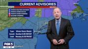
A powerful bomb cyclone is forecast to impact the East Coast this weekend, bringing the potential for a foot or more of snow across the region. The storm, driven by a coastal low-pressure system, is expected to begin on February 22-23, 2026, initially with rain in the upper 30s°F during daylight hours, transitioning to accumulating snow overnight as temperatures approach the freezing mark. Forecasters warn that the heaviest snowfall bands will develop east of the system, with urban centers such as Philadelphia, Baltimore, and New York City likely to see significant accumulation.
Meteorological models indicate the 32°F isotherm shifting southeastward, suggesting minimal snow accumulation northwest of I-95 during the day, but widespread wet snow is expected by evening. Residents in affected areas should anticipate 3-6 inches in city centers, with heavier totals possible in outlying regions. Authorities are urging the public to prepare for hazardous travel conditions, potential disruptions to transit, and localized power outages. Emergency services and city agencies are coordinating resources to manage snow removal and maintain safety as the storm moves through the Mid-Atlantic corridor.
This bomb cyclone represents a classic late-winter East Coast event, where rapid intensification of a coastal low can produce heavy snow, strong winds, and blizzard conditions in a short time. Weather officials emphasize monitoring updates closely, as timing, temperature fluctuations, and precipitation rates will determine the severity of the impact in metropolitan and suburban areas.
גאלערי
ווידעאס