סעטעלייט בילדער פון די חורבנות פון האריקעין מאליסע
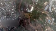
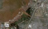
New satellite imagery released by Vantor on Wednesday, October 29, reveals the shocking extent of flooding and devastation left in the wake of Hurricane Melissa, which made landfall near Jamaica’s southwest coast earlier this week.
The high-resolution photos show large portions of Montego Bay, Negril, and surrounding parishes submerged under muddy floodwaters. Vast agricultural fields appear washed out, while entire neighborhoods are outlined by collapsed roads and isolated rooftops barely visible above the waterline.
Melissa, now recognized as one of the most powerful storms to ever strike the Caribbean, made landfall as a Category 5 hurricane, packing sustained winds of 185 mph and producing catastrophic rainfall across the island. Emergency management agencies continue to assess the damage, warning that full recovery could take months.
Despite the scale of the disaster, international aid is being mobilized quickly, with U.S. and regional partners coordinating relief flights and infrastructure support. Analysts note that the new imagery will help first responders map critical areas most in need of assistance as cleanup efforts expand across the country.
The storm has since moved north toward Bermuda, but its impact on Jamaica remains etched in satellite view — a sobering testament to the hurricane’s unprecedented power.
גאלערי
ווידעאס