צודרייטע ווידיאו פון טורנעידאו אין מיניסאוטע
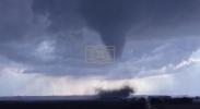
Wild drone footage has captured a powerful tornado tearing across farmland east of Truman, Minnesota, showing a large, dark funnel cloud actively rotating over open terrain. The storm appeared well-defined, with visible ground debris being lifted as the vortex moved across rural areas. Vehicles traveling along nearby roads were seen maintaining distance as the system passed through the region. The imagery provides a stark visual of the intensity associated with severe convective storms in the Midwest.
The event is linked to a broader severe weather outbreak that impacted southern Minnesota on April 13, 2026. Multiple tornado reports were recorded in areas near Truman and Amboy, alongside reports of large hail, some described as reaching baseball size. Meteorologists attributed the activity to a highly unstable atmosphere favorable for rotating storm systems. The outbreak underscores how quickly conditions can escalate during peak spring storm season.
At the center of such events are supercell thunderstorm structures, which are known for their persistent rotation and severe weather production. These storm systems can generate tornadoes, intense rainfall, and large hail depending on atmospheric conditions. In this case, the visual structure of the tornado suggests strong mesocyclone activity within the parent storm. Such dynamics are closely monitored by meteorologists to provide timely warnings.
גאלערי
ווידעאס