א חורבן נאך צאמפאל פון א וואסערפאל אין אינדוניזיע
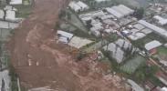
Dramatic drone footage has captured the scale of destruction left behind after a massive landslide struck Indonesia’s West Java region on January 24, burying homes and transforming entire neighborhoods into fields of mud and debris. The aerial images reveal rooftops partially submerged, collapsed structures, and scarred hillsides where the ground gave way without warning.
Authorities said the landslide was triggered by heavy rainfall that saturated the soil, causing unstable terrain to collapse down steep slopes. Emergency responders rushed to the affected areas as residents fled, with search-and-rescue teams working through thick mud to locate survivors and assess damage.
Local officials reported that numerous homes were either destroyed or rendered uninhabitable, forcing families to evacuate to temporary shelters. Infrastructure, including roads and power lines, was also damaged, complicating rescue operations and slowing aid delivery.
The disaster highlights Indonesia’s ongoing vulnerability to landslides, particularly during the rainy season, when intense downpours frequently destabilize mountainous regions. Experts warn that rapid development and deforestation in high-risk areas have increased the likelihood of such catastrophic events.
As recovery efforts continue, authorities are evaluating long-term relocation options for displaced residents, while monitoring nearby slopes for additional movement. The haunting drone footage from West Java serves as a stark reminder of the destructive power of nature and the growing risks faced by communities living in landslide-prone regions.
גאלערי
ווידעאס