נאציאנאלע וועטער סערוויס ווארנט פון שווערן שניי איבער צענטראל ניו יארק.
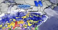
Central New York is facing a significant winter weather event as forecasts warn of widespread heavy snowfall beginning the afternoon of January 25 and continuing through January 26. According to the most accurate regional forecast and National Weather Service probabilistic mapping, high confidence exists for snow accumulations ranging from 16 to 20 inches across much of the region, including the Syracuse area.
The warning aligns with a broader Northeast winter storm system that began impacting southern portions of New York earlier on January 25. As conditions deteriorated, state officials moved quickly to respond. Governor Kathy Hochul declared a state of emergency to ensure rapid deployment of resources and to safeguard public safety as snowfall intensified and travel conditions worsened.
Local authorities implemented travel restrictions in affected areas, particularly around Syracuse, where heavy snow and reduced visibility posed serious risks to motorists. Emergency management officials urged residents to limit non-essential travel, prepare for potential power disruptions, and monitor official updates as the storm progressed.
Meteorologists emphasized that the snowfall totals are based on high-confidence data, signaling a strong likelihood of prolonged and disruptive winter conditions. Road crews, utility providers, and emergency responders remained on high alert throughout the region, working to mitigate the storm’s impact while prioritizing public safety.
As Central New York contends with one of the season’s most substantial snow events, officials continue to stress preparedness, caution, and cooperation as critical factors in navigating the storm safely.
גאלערי
ווידעאס