ניו יארק גרייט זיך צו א מאסיווע שניי שטורעם!
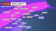
A major winter storm is expected to impact much of the tri-state area this weekend, with preliminary forecasts calling for 8 to 12 inches of snow across New York City, the Hudson Valley, nearly all of New Jersey, and Connecticut. Coastal areas may see slightly lower totals depending on the storm’s track and local temperature variations.
Meteorologists note that the exact snow totals will hinge on the path of the low-pressure system and the resulting atmospheric temperature profile. Updates throughout Friday are expected to provide a clearer picture of accumulation patterns and timing.
The Northeast is forecast to experience the heaviest snowfall Sunday afternoon and evening, followed by residual light snow early Monday. Travel disruptions are likely, with authorities warning of hazardous road conditions and potential delays on public transit. Parents are preparing for school closures or remote learning as local districts monitor storm conditions.
Once the storm passes, the region will face a period of extreme cold expected to persist for at least a week, compounding challenges for residents and commuters. Emergency officials are urging the public to stay updated on forecasts, avoid unnecessary travel during peak snowfall, and take precautions to manage exposure to the frigid temperatures that will follow.
גאלערי
ווידעאס