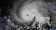
Hurricane Melissa’s rampage across the Caribbean stands as a stark reminder of nature’s unrestrained force. The Cooperative Institute for Research in the Atmosphere (CIRA) released timelapse satellite footage this week, capturing the storm’s relentless evolution — a breathtaking yet sobering chronicle of one of the most powerful hurricanes ever recorded in the Atlantic basin.
Melissa gained strength rapidly over warm Caribbean waters, escalating into a monstrous Category 5 hurricane before slamming into southwestern Jamaica last Tuesday. With sustained winds reaching a staggering 185 miles per hour, it became the most powerful hurricane to ever make landfall on the island, surpassing all previous records.
The storm’s ferocity left behind widespread devastation — flattened homes, uprooted infrastructure, and communities struggling to survive in its aftermath. Reports indicate that Jamaica has not faced a storm of this magnitude since 1988, underscoring the historic nature of Melissa’s impact.
After battering Jamaica, the hurricane tore through Cuba, the Bahamas, and Bermuda, leaving scars that will take years to heal. As of Wednesday, at least 67 lives have been lost across the affected regions, with thousands more displaced. Rescue operations continue as emergency crews fight through debris-filled streets and flooded communities.
Scientists point to unusually warm ocean temperatures as a key factor in Melissa’s explosive intensification, reigniting debates about preparedness and disaster response in vulnerable coastal nations. Yet beyond the science, the human toll remains most striking — stories of resilience, faith, and the enduring will to rebuild.
The satellite timelapse released by CIRA encapsulates more than meteorological data; it captures history in motion — the rise, wrath, and retreat of a storm that will be remembered for generations.
גאלערי
ווידעאס