די בליזערד וואס שלאגט ניו יארק און ניו דזשערסי
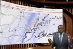
A powerful bomb cyclone continues to impact the Tri-State area, with heavy snowfall, intense wind gusts, and rapidly deteriorating visibility creating dangerous conditions across New York and New Jersey. Snowfall rates along coastal sections have reached two to three inches per hour, overwhelming plowing operations and forcing authorities to urge residents to remain off the roads.
Meteorological data indicates that the storm remains in a mature phase, with strong banding producing localized bursts of extremely heavy snow. Radar analysis shows persistent moisture feeding into the system from the Atlantic, sustaining high accumulation rates even as earlier snowfall totals have already reached significant levels. Additional accumulation of two to six inches is expected through the afternoon, with higher amounts possible in coastal communities where mesoscale bands continue to stall.
Wind gusts are compounding the impact by generating blowing and drifting snow that reduces visibility to near zero at times. These whiteout conditions have led to travel restrictions, flight cancellations, and disruptions to rail service across the region. Major highways are experiencing intermittent closures as emergency crews work to clear lanes and respond to stranded motorists.
Forecast models suggest that total storm accumulations could approach or exceed 30 inches in some locations, placing this event among the most significant February snowstorms on record for parts of the Tri-State area. The combination of high snowfall rates and sustained winds meets blizzard criteria in multiple counties, prompting extended warnings and emergency declarations.
Infrastructure strain is becoming increasingly evident. Power outages are being reported as heavy snow and strong winds bring down tree limbs and utility lines, while municipal crews are prioritizing access routes for emergency vehicles. Coastal areas face additional challenges from wind-driven snow and potential minor flooding during high tide cycles.
The storm is expected to gradually weaken as it tracks farther offshore, but hazardous conditions will persist into the evening due to lingering blowing snow, icy surfaces, and continued strong winds. Officials emphasize that even after snowfall tapers, travel will remain dangerous until plowing operations can fully clear primary and secondary roadways.
This nor’easter represents a high-impact winter event for one of the nation’s most densely populated regions, combining extreme snowfall rates, sustained blizzard conditions, and prolonged infrastructure disruptions. Residents are being advised to shelter in place, conserve power where possible, and monitor official updates as the storm progresses.
גאלערי
ווידעאס